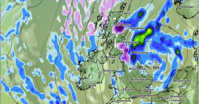
A 15-inch snow storm is set to sweep across Britain this month – with 17 counties forecast to be blanketed.
Weather maps from WXCharts show a large band of purple, representing snow, forming a ‘spine’ down much of the northern half of mainland Britain on Thursday 24 April. A large area stretching from Inverness to West Yorkshire is set to be covered, with peak snowfall reaching 2cm per hour. Other areas in the northeast will meanwhile see this fall as rain, with this being torrential in some coastal locations. Some isolated snow and rain showers are also forecast in North Wales. Another snow accumulation map shows that there will be plenty still on the ground by the following morning, reaching a total of 15 inches at its deepest in northern Scotland.
Three of the four home nations are forecast to be hit by the snow, with only Northern Ireland escaping untouched. Here’s the 14 counties covered in the forecast:
It comes as forecasters predict a colder turn to the weather in the second half of April – banishing the summer-like 23C temperatures we saw at the start of the month.
In his latest forecast, James Madden from Exacta Weather said: “The track of some further low-pressure areas with further heavy rain and unsettled conditions will more than likely continue to barrage across or near our shores and influence our weather for several days after the midweek one has passed through (a potentially named storm covered above), particularly more so in some parts to the south and west of the country.
“However, away from these areas and regions above, we could also see some brighter spells in between these developing showers and unsettled conditions.
“This will then more than likely pave the way for some additional and more potent wintry and cold weather that could even bring wintry precipitation, snow, or temporary snow, at the very least, to some much lower levels for very late in the season during next week and late April and, as covered in our 90+ days ahead spring forecast for these exact same dates and also prior to the correctly forecast mild to warm conditions of late.”
Plenty of wet weather will be coming our way over the next 24 hours – prompting the Met Office to issue a yellow weather warning for rain. This will be in place for Wales, southwest England until midday today, and will expire at 9pm in Northern Ireland.
Met Office Chief Meteorologist Matthew Lehnert said: “After a long spell of high pressure bringing dry weather and sunshine, gloomier and unsettled conditions are on the horizon. Low pressure has become established to the west of the UK bringing cloud, rain showers, and lower temperatures for many.
“More persistent and heavy rain is expected on Tuesday into early Wednesday. A low-pressure system near Portugal is of particular interest as it moves towards the UK, bringing with it potentially heavy rain and thunderstorms. We have issued a yellow warning for rain from midday on Tuesday until Wednesday afternoon. The warning covers southwest England, Wales, and the northwest of England.
“High rainfall totals are possible, but given the recent dry conditions, significant impacts are not anticipated. The situation remains under close watch, with further wet conditions anticipated on Thursday and another weather front moving in on Friday.”
At Reach and across our entities we and our partners use information collected through cookies and other identifiers from your device to improve experience on our site, analyse how it is used and to show personalised advertising. You can opt out of the sale or sharing of your data, at any time clicking the “Do Not Sell or Share my Data” button at the bottom of the webpage. Please note that your preferences are browser specific. Use of our website and any of our services represents your acceptance of the use of cookies and consent to the practices described in our Privacy Notice and Cookie Notice.


